Trail run to the top of Volandstind
StoriesJune 2024

A mountain like a pointed needle, forbidding and impregnable. However, on its long ridge, Volandstind offers perfect trail running conditions.

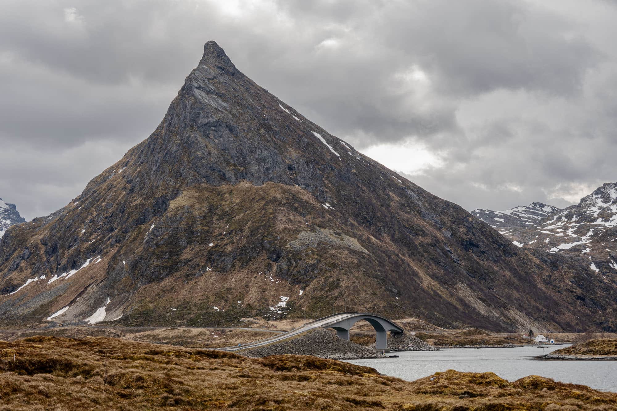
On the Lofoten Islands, even a simple drive by car is always an experience. On the way back from our hike on Ryten, we catch sight of a magnificent peak as we cross the curved bridges from Fredvang towards Ramberg. Volandstind rises up in front of us like a pointed needle and looks somehow impregnable, at least from this perspective. "Is there any way up there?" Of course, this is Falko's first reaction when an interesting peak comes into view and a quick glance at the digital map reveals that there is indeed a path leading up there. However, from our point of view, it is via the back side, i.e. from the south, which is far less impressive but no less beautiful. Looks like a plan.

Unconquerable?

Recovered from the hike up Ryten and after a hearty Sunday breakfast, we pack our trail running rucksacks and lace up our running shoes to put our plan into action. A good 40 minutes' drive later, we are standing at the foot of Volandstind with a cold wind whistling around our noses. But by now we have become accustomed to the "7° C and windy" weather, i.e. the Nordic spring. We have decided to tackle Volandstind from the east. On the one hand, we are not yet familiar with this route and on the other hand, the ascent via the west side, which leads past Geitedalsvatnet, is quite damp and muddy, as we found out on an evening photo excursion last year. The path on the east side, on the other hand, turns out to be solid. The first few meters in altitude are not exactly perfect trail running terrain, rocky, bumpy and a little difficult to run, but after around 200 meters in altitude, this is forgotten.

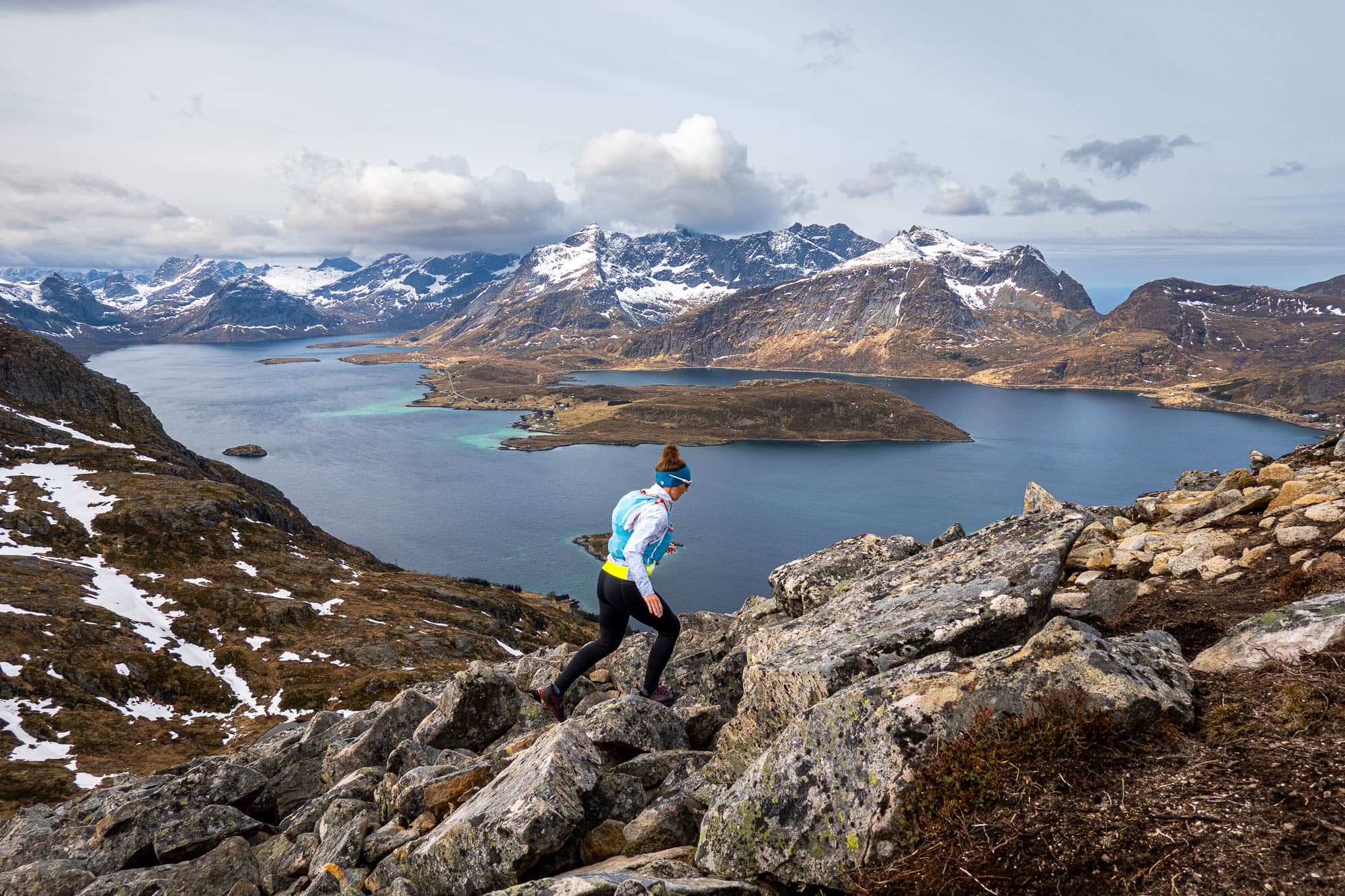
From Nesheia, the path heads straight north, first over the broad ridge and later along the ridge. While Falko runs forwards or backwards with his camera, I try to find my rhythm and struggle with the terrain. The trail is rough and stony almost everywhere and somewhat technically demanding, but the effort is worth it in the end, because the view from the summit or even from the slightly lower peak in front of it is simply stunning. Torsfjortinden, Ryten and Fuglhuken are lined up on the left, while Stjerntinden, Stortinden and Moltinden tower up on the right. In between, on the right-hand side, lies the picturesque village of Ramberg with its sandy beach in the turquoise and white colors typical of the Lofoten Islands. On the left, the imposing bridges Kubholmenleia bru and Røssøystraumen bru span several small islands and provide an uncomplicated connection across to Fredvang.

Pure Sightseeing.

The beautiful landscape, the winding roads and bridges and the many small, colorful wooden houses look like a miniature landscape from up here, and we would love to sit here forever and watch the hustle and bustle. But the incessant wind doesn't care about our wishes. As we are just standing around, snacking on muesli bars and not moving around much, we get cold relatively quickly after the strenuous climb. So, with a heavy heart, we tear ourselves away from the fascinating sight and make our way back.

We return to the main summit via short, steep and sloping passages and continue along the path towards the valley. The stony path also requires our full attention on the descent and quickly makes us forget our cold fingers. At Nesheia, we turn left and bypass some boggy patches before we reach the road again over rough and smooth.

As steep, forbidding and unconquerable as Volandstind looks from the north, it is easy to climb from the south. Anyone looking for a short but challenging trail run or simply a destination for a hike with spectacular views will find a needle in a haystack at this peak.

Information about the route

Trail running to Volandstinden – 457 m
T2 (E1)

A pointed, tooth-shaped mountain that appears quite tame from the other side: Volandstinden impresses with its incredible views from its exposed summit over the fjord and mountain landscape of the Lofoten Islands.

Facts & figures

Grade

Seriousness

Total time

Ascent

500 m

Descent

500 m

Highest point

457 m

Distance

5 km

Region

NorwayLofoten

Activity type

Book a guide

With an experienced guide, you will experience this tour with new impressions and the good feeling of being safe on the road.

Seen from Fredvang, the starting point for Ryten, the 457 m high Volandstinden looks like an almost unclimbable mountain. Good to know that there is a good hiking trail to the summit from the south side. From the parking lot just before Skjelfjorden, we overcome the first 250-metre-high terrain step via a south-west ascending path. We then reach a kind of high plateau with various small lakes and ponds, which leads down to the west towards the road (E10). From there, a small path also leads here, although it is quite muddy in many places and sometimes difficult to recognize.

From here, we follow the easily recognizable path more or less constantly in a northerly direction, always roughly along the southern rib of the Volandstinden over some scree fields and short, more exposed sections until shortly before the summit. Here there are a few more easy rock towers to overcome before we finally reach the highest point at 457 m above sea level. From the summit of Volandstinden there is a tremendous panorama in all directions, which is truly unique.

For the descent, we use the same route as for the ascent.

Short, somewhat exposed sections on the otherwise easy hiking trail. A few small scree fields have to be crossed in the upper section.

The summit area slopes very steeply to the north.

Best season

April to October.

Arrival

By car from Stamberg on the E10 to the junction in the direction of Skjelfjorden (Nordfjord).

Shortly before the first houses there is a single building with parking facilities.

Parking lot also suitable for campers.

Starting point

Parking lot on the small road towards Skjelfjorden.

Alternatively, you can climb up from the western side, but this ascent is relatively muddy and not as beautiful as from the eastern side.

View on Google Maps

Good to know

Breathtaking views, especially from Ramberg over Fredvang to Selfjord.

The ascent is equally suitable for trail running and mountain running, only the first part from the east is a bit rooted.

Date of the information

May 2023

Share article

Trail & Chill Newsletter

Receive a relaxed mountain feeling and other exciting news about trail running, hiking and photography straight to your inbox.
You can find our privacy policy here.

About the author Marina Kraus

Marina Kraus
Marina loves being outdoors—step by step, uphill, downhill, right in the thick of things. As a hiking guide with the Swiss Mountain Guides Association, she plans and leads tours for our guests, always on the lookout for special trails, scenic rest stops, and moments that will stay with them forever. She loves being outdoors with others – whether over rocky ridges or through deep green forests. And for those who haven't been able to join her (yet), she writes stories from the roadside: honest, approachable, and with that certain beAnywhere feeling.
To the biography