Trailrunning from Haukland to Uttakleiv

Route information is available for this story:

Trail running Haukland – Uttakleiv via Mannen

T3 (E1)
StoriesJune 2024

If you like trail running, you will love this track. The tour above the most beautiful beaches of Lofoten is a must for anyone who appreciates the combination of sea and summit.

Some days start so badly that they can only get better. This day is one of them and before we can start our trail run from Haukland to Uttakleiv, we get into a really bad mood. In the end, however, we are rewarded with an unexpected summit and a breathtaking view.

The roads on the Lofoten Islands are not exactly the best, but who is surprised: icy winters, snow, frost and moisture leave their mark, often in the form of potholes in the asphalt. Most of the time, we manage to get around the holes, which are sometimes as big as if they could swallow up an entire vehicle. But just before we reach the parking lot at Haukland Strand, our starting point for this tour, we unfortunately miss one of the deeper ones and our van crashes right through it. There is a huge bang, it feels like all the furniture breaks out of its anchoring and then nothing works for a while, apart from the warning message on the display. We roll a few more meters to the side of the road, but the engine is off and won't start again for the time being. A great start to the day, we think to ourselves and with grumpy faces we set about troubleshooting. 20 minutes, an internet search and a call to the garage later, we have actually managed to fix the problem, get the engine running again and we are finally standing on Haukland beach. I pay the 40 crowns for the parking fee with a smile, happy to be able to park here at all. Then we set off.

Perfect camouflage

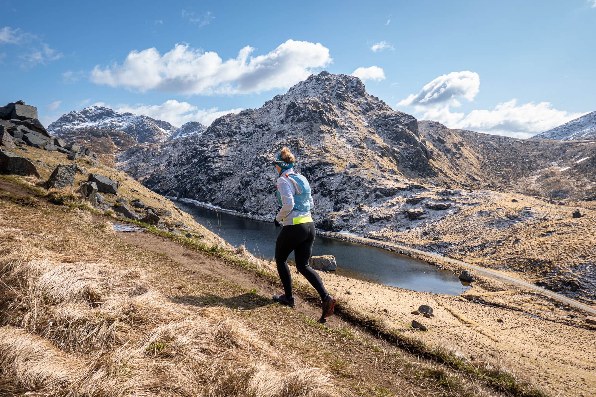
Our first steps take us past the entrance to the tunnel that leads through the mountain to Uttakleiv, across the road. From now on it's uphill. To warm up, we follow the small road towards Solstadvatnet, but shortly before we reach the lake, which remains hidden to most visitors who only come for the sandy beach, we turn left and follow the hiking trail. We quickly gain altitude in short hairpin bends and after a short time we reach the small Klumpan pass.

Our plan for this tour was to walk over this crossing to Uttakleiv and around the Veggen back to Haukland. We skipped further research on this trail and are now quite surprised to see that there is another hiking trail to our left leading uphill. So why not climb a little further up to the next hilltop and enjoy the view. But as is the case with "the next hilltop", there is usually more to come and so we follow the path, which is a little muddy but otherwise easy to walk on, until we reach the summit of the Mannen (as we check later on the map).

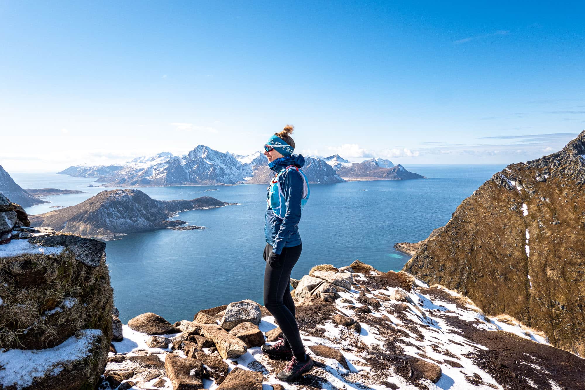
We hadn't expected such a magnificent view and the extra 200 meters in altitude were definitely worth it. The view over to Veggen and down to the turquoise waters of Haukland beach is truly overwhelming and we both have big grins on our faces. After all, we are looking at the most beautiful beach in Norway, according to the Norwegian newspaper Dagbladet. Behind us, Himmeltind rises into the sky and in front of us lies the small lake Vasskarvatnet in a hollow. Sometimes you just have to follow your nose and the rest takes care of itself. The pothole disaster of just over an hour ago is long forgotten and at this moment we are simply enjoying our good fortune.

Let your eyes wander

A muesli bar for refreshment, then we set off on the descent. Instead of potholes, up here we encounter muddy paths that are at least just as treacherous and, coupled with the little snow that is still lying here, this results - at least for me - in a running style that is more reminiscent of raw eggs than solid trail running. I can probably still work on my grace, but in the end I also make it back to the Klumpan crossing unscathed. Back on our planned route, we follow the path towards Uttakleiv, which looks like an old road on the north side and on which we can run side by side and make good progress.

Back (almost) at sea level, we follow the road for a while to reach the parking lot near Uttakleiv beach. In April and May, there is actually hardly anything going on here, only a few cars are parked in the parking lot and a few tourists have made themselves comfortable with their packed lunches in the midday sun and with a magnificent view of the beach with its spherical rocks. For us, on the other hand, the next few minutes are rather uncomfortable, as our route takes us further along the north side of the Veggen in its shade. The air temperature is still quite cool at 6°C and without the warming rays of sunshine, we immediately feel a little shivery. But we have no choice for the next kilometer, so we put on our collars.

Thanks to the flat road, which was the official connection to Uttakleiv until 1998 when the tunnel was opened, we make rapid progress and within a few minutes we reach the westernmost section of our trail running loop around Veggen. Back in the sunshine, we tackle the last few kilometers and are rewarded once again at the end with a tailwind, sun on our faces and a view of Hauklandstrand.

At ten kilometers, this trail from Haukland to Uttakleiv is not exactly one of the longest trails we have run so far, but it is definitely one of the most beautiful. The detour to the summit of Mannen was definitely worth the extra meters of altitude, the views from high up are extremely impressive and the flat final stage allows us to enjoy this incredible landscape again at sea level. For us, this trail is definitely one of the top runs in the Lofoten Islands.

Information about the route

Trail running Haukland – Uttakleiv via Mannen
T3 (E1)

Between solitude and crowds: anyone tackling the Haukland–Uttakleiv circular hiking trail should be prepared for large crowds of cruise ship passengers. From the summit of Mannen, there is an impressive view of the Caribbean-like sandy beaches in the bays.

Facts & figures

Grade

Seriousness

Total time

Ascent

464 m

Descent

456 m

Highest point

400 m

Distance

10 km

Region

NorwayLofoten

Activity type

Book a guide

With an experienced guide, you will experience this tour with new impressions and the good feeling of being safe on the road.

Route description

We start our route description in an anti-clockwise direction and walk from the Haukland parking lot along the asphalt road, which is closed to car traffic, slightly uphill towards Solstadvatnet, a small lake at an altitude of around 65 meters. Shortly before we reach the lake, we turn left onto the clearly visible hiking trail up to a small pass. In a handful of serpentines, the path leads up well-trodden and without any difficulties worth mentioning. Here we now have the choice of descending directly to Uttakleiv on the almost road-like route to the north or keeping to the left and continuously gaining height to tackle the summit of Mannen. This route is not marked on the official map of Norway, the Norgeskart, but in reality it is impossible to miss.

Partly a little muddy and over short, steep steps, the hiking trail leads us up to the summit of Mannen, which is exactly 400 meters high and is garnished with incredibly beautiful views. From this somewhat exposed point, we can follow our entire onward route down to Uttakleiv until Veggen, towering in front of us and the Atlantic Ocean, pushes itself into our field of vision and obscures the outer part of our way back.

From the summit, we follow the path back down to the small pass crossing and now keep left. The path now simply leads past a small lake (Lomtjønna) and, soon losing altitude, descends in a few long serpentines and finally joins the road that leads through the tunnel back to Haukland. However, we turn right and then left again at the only crossroads in Uttakleiv to reach the famous sandy Uttakleiv Beach. From here, the road, which is closed to traffic, follows the logical route around Veggen without any difficulties or significant differences in altitude and surprises us again and again with incredible moments below the steep face of Veggen and with breathtaking views of the Lofoten coastline.

Finally, the path turns east and we can already see our starting point, Haukland, and the white sandy beach in the turquoise-green bay.

Difficulty

Easy hiking trail with short, steeper sections along the Mannen. These can be very slippery and muddy when wet after rain or snowmelt and are sometimes in terrain where there is a risk of falling.

The summit of the Mannen is exposed and drops steeply on all sides.

The mostly flat path around the steeply sloping Veggen on the west side is a former road and has been developed accordingly.

Best season

April to October

Early in the year, individual snowfields in the upper part of the Mannen can still make the ascent difficult.

Arrival

The easiest way to get here by car is to come from Leknes on the E10, turn right after the bridge over the fjord (Offersøya) and follow the small road for about two and a half kilometers. Then turn left and follow the road to the parking lot at Haukland Beach (information center). You can continue through the following tunnel to Uttakleiv within a few minutes.

Starting point

We started from Haukland, but the tour can just as easily be tackled from the Uttakleiv parking lot in either direction.

There is a charge at the Haukland and Uttakleiv parking lots. Both starting points are connected by a short road and a tunnel.

At the parking lot in Uttakleiv, a limited number of parking spaces can be used by motorhomes for a fee. WC and washing facilities are also available there, but it is not a campsite.

View on Google Maps

Good to know

The circular route is often chosen by tourist groups when a cruise ship is anchored in Leknes harbor.

The view from the summit of Mannen to Veggen, which lies directly in front of it, is impressive. Himmeltinden rises steeply in the background.

The route is suitable both as an easy yet varied half-day hike and as a trail run.

Share article

Trail & Chill Newsletter

Receive a relaxed mountain feeling and other exciting news about trail running, hiking and photography straight to your inbox.
You can find our privacy policy here.

About Marina Kraus

Marina Kraus
Marina feels most at home outdoors – one step at a time, up and down, fully in the moment. As a certified hiking guide in training (Swiss Mountain Guide Association), she plans and leads tours for our community, always on the lookout for hidden paths, scenic break spots, and moments that stay with you. She loves being out there with others – whether it's across rocky ridgelines or through deep green forests. And for those who (just yet) couldn’t join, she shares stories from the trail: honest, down-to-earth, and packed with that special beAnywhere feeling.
Read biography