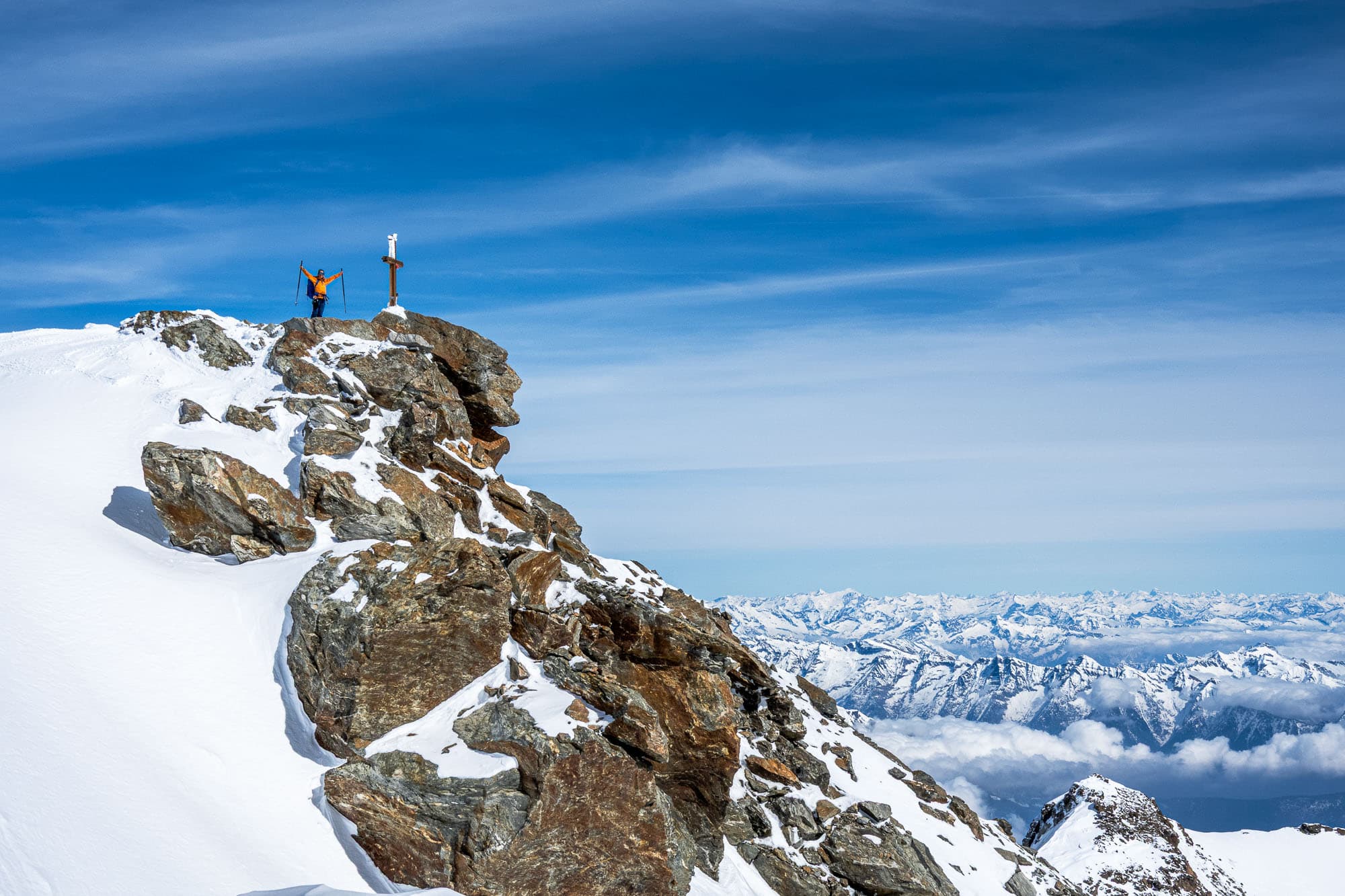

Shhh... shhh... Slowly, step by step, meter by meter, I push myself toward the Fletschhorn summit. It's a rather undignified sight, this picture of me just before the summit – there's no trace of alpine elegance here.
At 3,985 meters, the Fletschhorn is really no giant, and yet it completely threw me off balance on this high-altitude ski tour, as they say. The fact that I still managed to reach this alpinistically interesting summit is mainly thanks to my tour partner Evelyn, who – without putting any pressure on me – repeatedly managed to motivate me to make the next kick turns. Not everyone can do that, and it only works if you have enough reserves yourself in these moments. Hats off!
Acclimatization tour to Lagginjoch
We arrived the day before and shortened the first, rather unspectacular 850 meters of elevation gain by taking the cable car to Kreuzboden at 2,399 meters. Our plan for today is to make a leisurely ascent via the Weissmies huts (https://weissmieshuette.ch) (2,726 m), leave some of our luggage there, and then tackle the approximately 800 meters of elevation gain to Lagginjoch as an acclimatization ski tour. It's a technically easy tour, but it offers magnificent views of the Laggin valley and the Gondo valley gorge with the small hamlet of Simplon deep down in the valley, and a few rewarding slopes on the descent.
We take it easy and soon head east away from the ski slopes towards Lagginjoch. From here, it's just under 500 meters of elevation gain. We follow old tracks and, after a good hour's climb, reach the upper end of the Lagginjoch glacier, which is now in a pitiful state. From here, it's perhaps another 30 meters of elevation gain to Lagginjoch. Not much, really, and yet I feel like I've just returned from a half marathon. Apparently, I'm not quite acclimatized to the altitude yet – how will it go tomorrow on the Fletschhorn, which is almost 500 meters higher?
I start the return journey feeling a little sheepish. With a few beautiful turns, we rush down the perfectly sloped hills west of the Lagginjoch and quickly reach the piste again, which we follow for a few minutes to the Weissmies hut. This is the end of the line for today. We spend the rest of the day chilling, chatting, eating, and drinking. Although – unfortunately, I have to qualify that about eating, because I simply have no appetite...
Altitude problems at less than 4000 meters? Of course it's possible!
Roberto, the hut warden of the Weissmies hut, and his team cook a really delicious dinner. It pains me all the more that I can hardly get a bite down. It's one of the typical symptoms of altitude sickness: loss of appetite is often the first symptom, followed by headaches and dizziness. It's a vicious circle: during the day, the body is challenged, then it doesn't get the energy it needs, and finally it is denied sleep to recover. At least a few calories are added during the night, because at some point my stomach growls so loudly that I get up and eat a few cereal bars in the dim light of the hallway.
The Fletschhorn: better as a ski tour or a high-altitude tour?
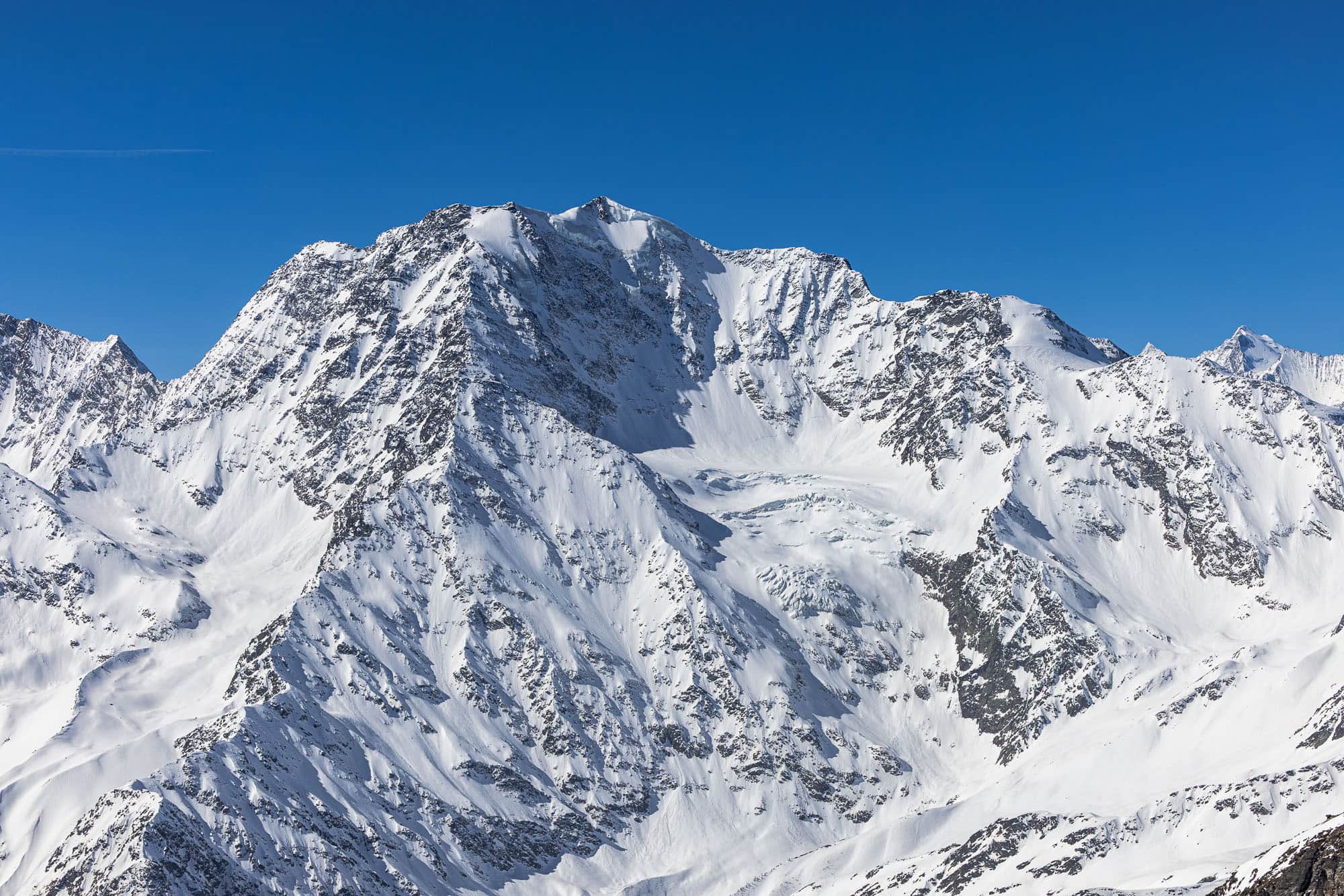
The Fletschhorn, which is just under 4000 meters high, is often visited in summer during the high-altitude touring season. The normal route via the Tälli Glacier and the upper part of the Grüebu Glacier is particularly popular, and the Fletschhorn–Lagginhorn traverse is also very popular. In winter, however, the mountains on the eastern side of the Saas Valley tend to be overlooked. They are not typical ski touring mountains – the Lagginhorn in particular cannot be climbed on skis, and the Weissmies is also more popular in summer.
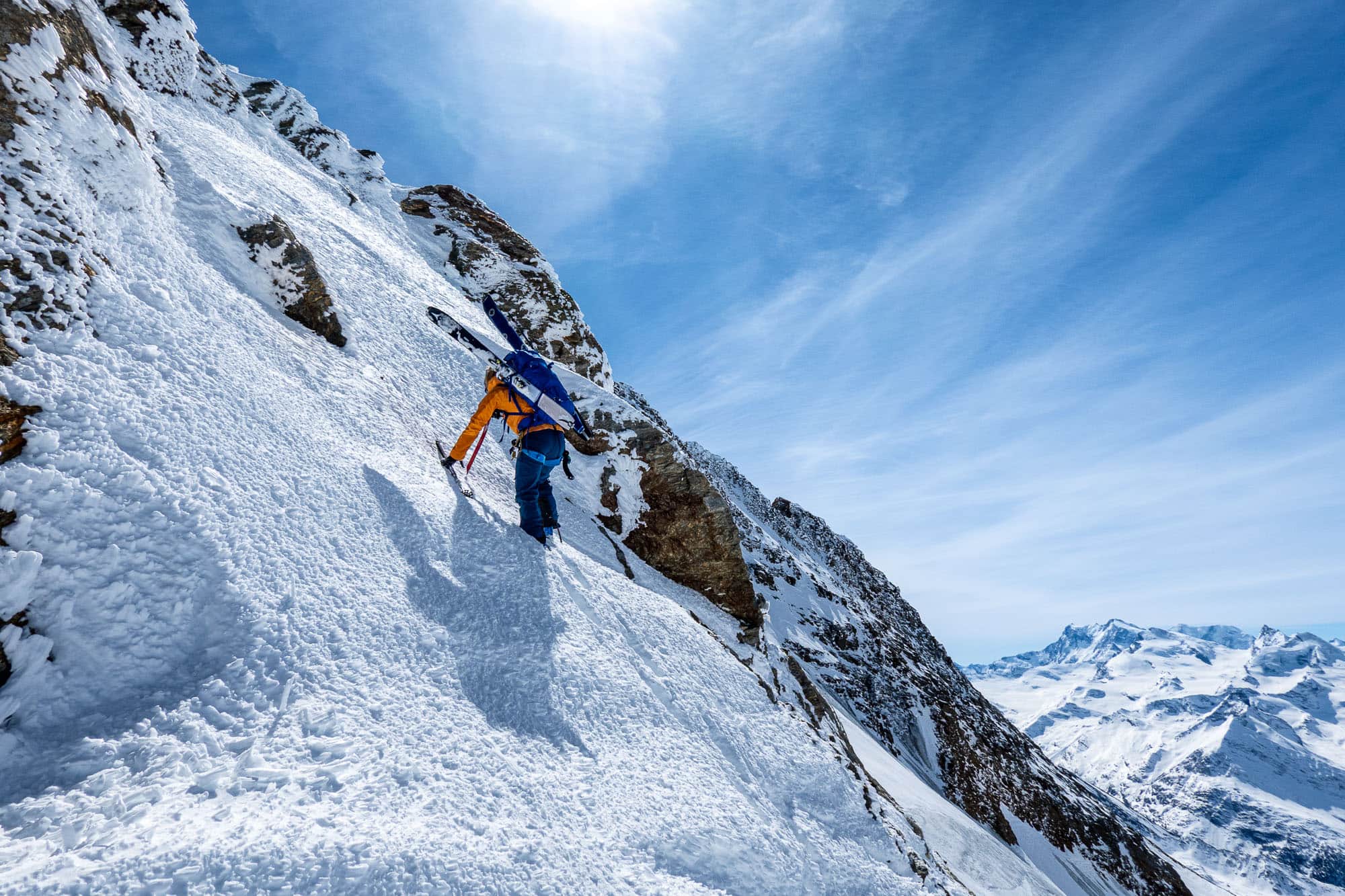
During our ascent, we ask ourselves whether climbing in winter isn't actually the more beautiful option. Due to the melting of the glaciers and firn fields, the approach to the Grüebu Glacier in late summer is a difficult scree landscape with boulder fields. We, on the other hand, can ascend on skis to around 3,300 meters before the terrain becomes too steep and we switch to crampons. Thanks to good, stable snow conditions, the following meters to the junction with the foothills of the Jegigrat are easily manageable, and soon we are standing on the wide glacier ridge at around 3,500 meters. Ahead of us, the view opens up onto the rest of the route across the Grüebu glacier, which is rugged in places but today is well covered in snow all the way up to the summit of the Fletschhorn.
The Fletschhorn has a special history. Until the 1950s, the mountain just barely exceeded the magical 4,000-meter mark. With increasing erosion, the melting of the ice and firn cap at the summit, and more accurate surveying techniques, it lost this status, but soon made headlines in other ways. The municipality of Saas-Grund planned to raise the summit back to 4,000 meters through construction measures – a project that was ultimately rejected by the canton of Valais. The Fletschhorn is now 15 meters short of being accepted back into the illustrious circle of Switzerland's highest peaks. However, this does not detract from the diversity of its routes: with the traverse to the Lagginhorn, the Breitloibgrat from the northeast, and the Wiener Route through the north face, there are several, sometimes challenging ascents to this summit in addition to the normal route, which presents itself as a mighty bastion towering over 2,000 meters above the Simplon Pass, especially from the [Breithorn] (/article/ski-tour-breithorn-simplon) above the Simplon Pass.
Descent via the Grüebu Glacier
After the so-called breakfast spot, we tackle the last 500 meters of elevation gain. While the altitude is now really getting to me, Evelyn is cruising along comfortably. Our slow pace to the summit is down to me – she deserves a lot of respect for her subtle but constant motivation, which somehow gets me to the top after all.
The striking summit cross, which was renovated in the summer of 2025, marks the end of the exertions for me and the start of the descent for us. We choose the route over the Grüebu Glacier down into the high valley south of the Rothorn ridge, which has no name on the map. This remote corner of the Saas Valley with the small Grüebusee and Fellsee lakes attracts little tourist attention. There are no cable cars here, only a few hamlets romantically nestled on the mountainside bear witness to its use as extensive alpine pastures during the summer months.
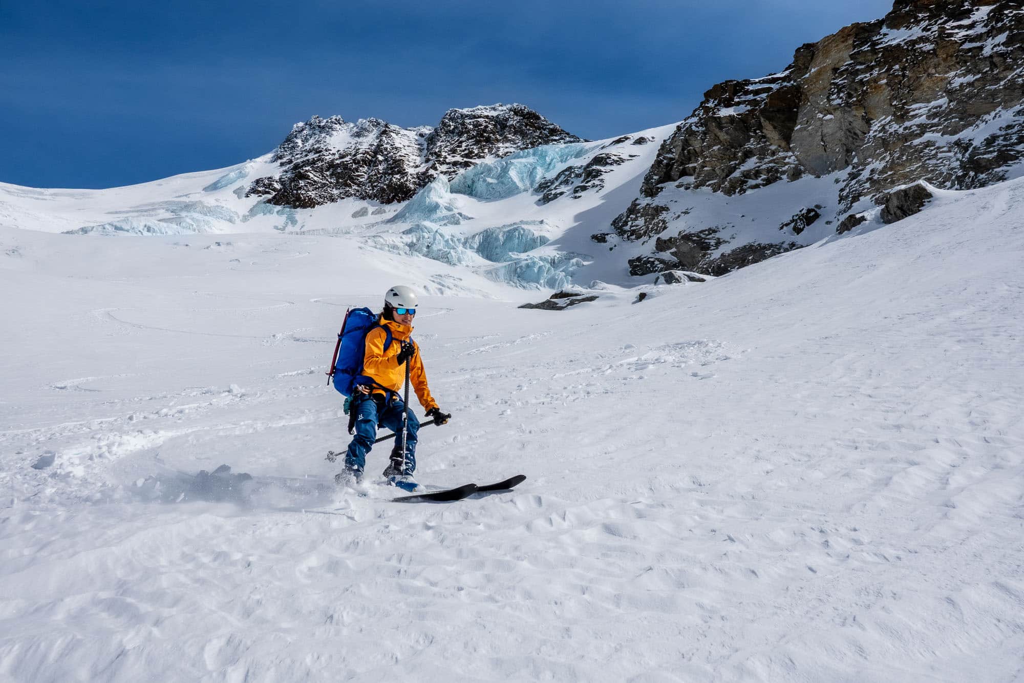
Thanks to the well-covered glacier and beautiful snow, we quickly lose altitude and soon find ourselves in the expansive valley basin. However, danger lurks beneath the white blanket of snow, as the block glacier and glacial lakes threaten to drain into Saas-Balen far below. As the glaciers melt, the risk of debris flows and flooding increases, threatening entire villages in mountain regions with increasing frequency.
Our altitude, on the other hand, has decreased – and with it, my well-being has improved significantly. After managing to descend the last patches of snow on the alpine road almost all the way to Saas-Balen, I feel fresh and lively again. The effect of descending just a few hundred meters in altitude when experiencing altitude problems should never be underestimated. It can bring about a significant improvement in symptoms.
The post bus, which runs regularly all year round, takes us back to our starting point in Saas-Grund in a few minutes, where we celebrate our successful ascent of the Fletschhorn as a ski tour with a cool Rivella. Thank you, Evelyn, for mentally pulling us up the mountain!
